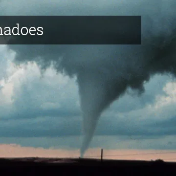
The National Weather Service (NWS) has issued alerts for severe thunderstorms and potential tornadoes across the central and southeastern United States, raising concerns for widespread severe weather impacts. Residents in the Plains, Midwest, and Southeast should remain vigilant, with tornadic activity considered a significant threat. Notably, areas such as Oklahoma and North Texas are on high alert for severe thunderstorms that could develop into tornadoes. NWS officials warned, “Thunderstorms are expected to begin in the morning hours Tuesday and could escalate through the day, causing damaging winds and hail in addition to tornadoes.”
In addition, meteorologists are specifically monitoring a cold front that will move through the region, resulting in a volatile atmosphere conducive to severe storms. This pattern is expected to bring strong to severe thunderstorms to an expansive area, particularly affecting Dallas-Fort Worth on Tuesday morning. Radar visuals indicate potential for hail and damaging winds, with reports indicating wind gusts could exceed 60 mph in the strongest storms.
Stephen W. Smith, a meteorologist based in Dallas, stated, “We expect storms to be fierce with heightened risk for tornadoes, especially in the afternoon hours. The conditions are ripe for potential tornadic activity, so residents should have severe weather plans in place.”
Furthermore, emergency management officials are urging residents to stay informed via local updates and warnings. In the case of a tornado warning, individuals are advised to seek shelter immediately in a sturdy building or designated storm shelter. The NWS emphasizes the importance of preparedness and awareness during such severe weather events. Severe weather conditions may extend to the East Coast later in the week, with forecasters predicting heavy rainfall and possible flooding as the system progresses eastward. Communities across affected regions are encouraged to stay tuned to the latest weather developments and prepare for rapidly changing conditions.